UPDATE! New Detailed 2011 District Maps
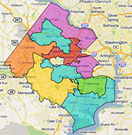
NEW! Fairfax County Detailed District Maps
 These Fairfax County district maps are recently updated and include detailed streets, polling locations and other important information about each Supervisor district. The link above goes to a gallery page that includes a Fairfax County map with each Suervisor District identified and then more detailed maps of each district. If you don’t know which district you live in, open the main Supervisor District map first to locate your district and then open the more detailed map of your district. NOTE: These changes are applicable as of September 1 after the upcoming primary on August 23rd.
NOTE: These House and Senate districts are not quite finalized. Once finalized we will replace this note with a final notice. Please check back at the end of July.
Maps you can print below
The updated 2011 district maps below are provided by Fairfax County. Click a link to open the PDF file. Right click and select Save link as… to download the file to your computer.
FX CO. Supervisor Districts (2011) (PDF)
FX CO. Detailed Supervisor District Maps (2011)
VA State House Districts (2011) (PDF)
VA State Senate Districts (2011) (PDF)
U.S. House Districts (2011) (PDF)
Find Your Poll, Districts, and Registration Status


